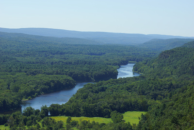
Panoramic Vistas & Waterfalls - Exploring Raymondskill Falls, Hackers Falls, and Cliff Park TrailOVERVIEW This post was updated on March 1, 2021. If you like spectacular panoramic vistas, this hike is for you... The Cliff Trail has some of the best panoramic vistas in the Delaware Water Gap National Recreation Area and has become one of my favorite fall hikes. From the four overlooks along the cliff, you can see Pennsylvania, New Jersey, and New York on a clear day. During the peak foliage season in the Pocono Mountains, the colors stretch as far as the eye can see with the mighty Delaware River carving its way through the valley.
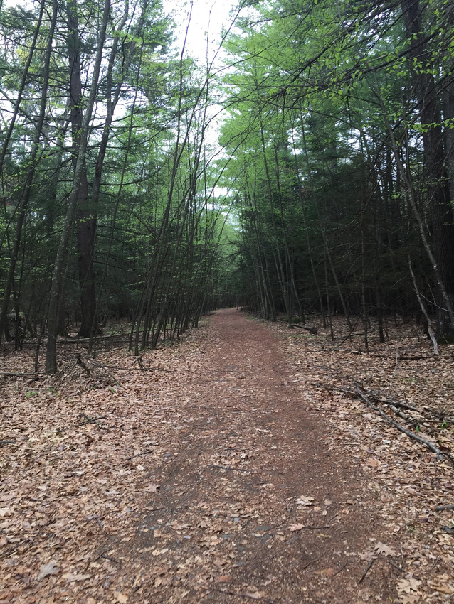
Getting to these views takes a little work but the effort is definitely worth the reward. From the parking area on Raymondskill Road, make your way across the road to the Cliff Trail/Hackers Trails. Depending on how much time you have, you can make a right and stay on Cliff Trail (white blaze) or do the full loop and go straight to Hackers Trail (yellow blaze). You will gain 300 feet in elevation in about a half-mile as you head up Cliff Trail. The trails are well maintained and a mix of gravel and dirt. After the initial uphill climb, the trail will level out along the ridge giving you time to catch your breath at the Tristate Overlook. This is the first of four overlooks along the cliff. When exploring at each overlook, use caution and common sense, and stay behind the fence barrier. As you make your way to the next overlook, keep an eye out for hemlock trees, deer, bears, and Bald Eagles. The next two overlooks give you views of the Delaware River and the monument at High Point State Park (looking northeast). The last of the four overlooks gives you a birdseye view of downtown Milford, PA. There are two waterfalls in the area. The first is the impressive Raymondskill Falls (located at the trailhead). Raymond Skill Falls is a three-tiered waterfall that plummets 178 feet. If you add the drops from each tier together, the waterfall is only a few feet shorter than Niagara Falls. There are two viewing platforms for visitors. The lower platform provides you with the best place for photo opportunities. The second waterfall is located at the top of the ridge if you follow Buchanan Trail (orange blaze) from Cliff Trail. Hackers Falls is short but impressive, especially after a good rain. The fan shape of the waterfall drops sharply into Raymondskill Creek before feeding into Raymondskill Falls. There is a small area at the base of the falls to take a break. PHOTOS FROM THE TRAIL
TRAIL NOTES RESTRICTIONS PET FRIENDLY TRAIL MAP TRAIL STATS White Blaze - Cliff Trail. Moderate 2.8 miles, one-way. GPS, HOURS & PARKING The trailhead is located on Raymondskill Road. GPS coordinates: 41.290291,-74.840466.
NEARBY ADVENTURES
MORE OF MY TRAIL NOTES
Resources: NPS Note: Masks are required indoors and outdoors. When indoors, masks are required anytime you're with people outside of your household, even if you're socially distant. Face masks are required in all federal buildings and on federal lands. Always check local guidelines before traveling.
Keywords:
Cliff Trail,
Delaware Water Gap National Recreation Area,
fall foliage,
highpoint state park,
Hiking,
hiking blog,
keep nature wild,
leave no trace,
overlook,
pocono mountains,
raymondskill falls,
vista

Comments
No comments posted.
Loading...
|
COVID-19 PRECAUTIONS
LEAVE NO TRACE
DISCLAIMER |